
Slideshow:
Glasgow has a Green Space Strategy known as ‘Open Space Strategy’ - https://www.glasgow.gov.uk/index.aspx?articleid=17192) which aims to achieve the following objectives:
Placemaking
Climate change adaptation
Connectivity (among green spaces as well as to citizens)
Well-being
Biodiversity
At the same time, as a result of climate change (1971-2014) average rainfall in the Glasgow Clyde Valley region has increased by 21%; maximum temperatures increased on average by 1.21°C; the number of heat waves increased with 6 days whereas the number of snow days decreased by 32% (Glasgow LCLIP, 2015) The UK Climate Impact Programme (UKCIP 2015) predicts that by 2050 Glasgow will experience wetter winters and drier summers – with a decrease in the annual average rainfall of up to 10% but greater seasonal variation (i.e. heavy winter rain events, currently experienced around once every two years, may become between 15% and 20% heavier); the average temperature in the summer will increase by 2.4°C. Thus, widespread flooding increasing during winter and storm periods as well as overheating may become key hydro-meteorological risks for Glasgow.
The challenge then is to integrate Green Infrastructure (GI) into climate change adaptation for a just transition to climate-proof the city, with priorities to improve to local ‘place’ via flooding / overheating prevention.
Policy questions addressed by the CityLab:
- Could the ecosystem services provided by GI towards climate change adaptation (especially in terms of flooding and overheating) be mapped across the city?
- How are such ecosystem services distributed across the city in relation to social deprivation (i.e. as an inverse of ‘Well-being’)?
- What implications does such mapping have for ‘place-making’?
Data for the analysis reported here came from two sources:
- Glasgow City Council: Green Infrastructure data
- Scottish Government: Scottish Index of Multiple Deprivation 2016 (SIMD2016)
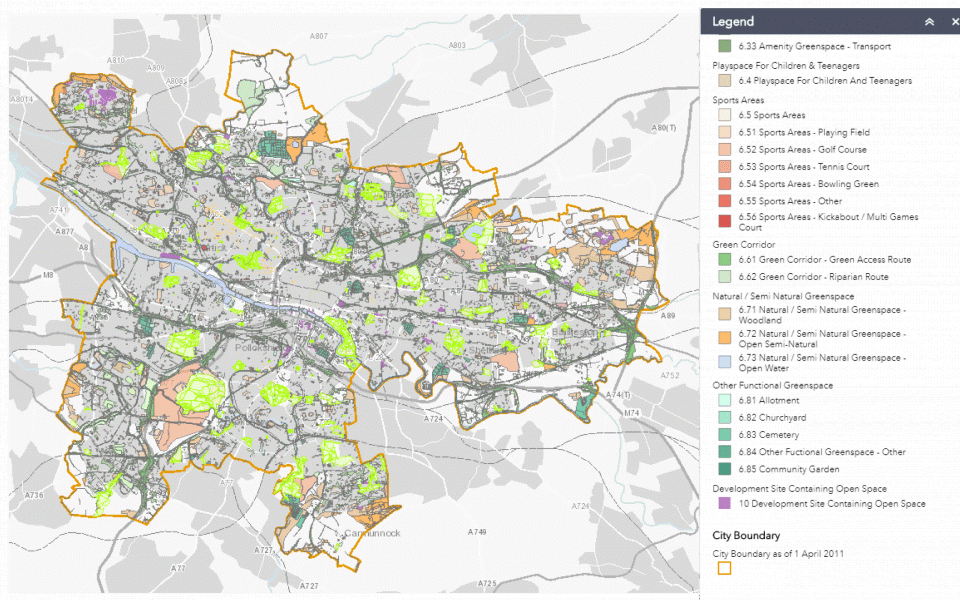
The Green Infrastructure data for the city is available under Planning Advice Note 65 (PAN 65) of the Scottish Government . that requires local authorities to map their existing green and blue spaces. These maps are publicly available (Glasgow City’s map here: https://glasgowgis.maps.arcgis.com/apps/webappviewer/index.html?id=a968a2a7fa514eb1ac66abc571949c2e). The GIS layer underlying this map was provided by the Glasgow City Council
The Scottish Index of Multiple deprivation (SIMD) 2016 is the Scottish Government’s official tool for identifying concentrations of deprivation (or lack of well-being) in Scotland. SIMD combines seven different aspects (known as ‘domains’) of deprivation:
- Income
- Employment
- Health
- Education, Skills and Training
- Geographic Access to Services
- Crime
- Housing
These domains are measured using 38 indicators to form ranks for each domain. They are then clustered into ‘Data zones’ (each containing approx. 500 people), which are ranked from 1 being most deprived to 6,976 being least deprived. Each of the seven domain ranks is then combined to form the overall SIMD. This provides a measure of relative deprivation at data zone level, so that it indicates one data zone is relatively more deprived than another but not how much more deprived.
The methodology used to construct SIMD is given in SIMD 2016. Data is available at: https://www.gov.scot/simd
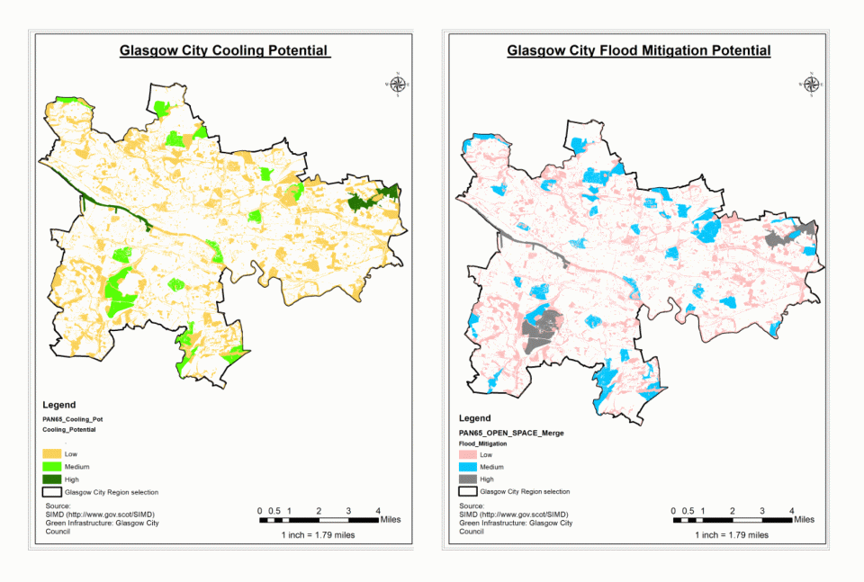
The Green Infrastructure data (hereafter PAN65 data) was used as the basis to estimate the cooling potential of a location as well as its flood prevention potential.
Cooling potential estimation:
The hypothesis underlying the estimation of cooling potential is as follows:
- Cooling provided by different types of GIs is similar
- Cooling potential depends on the extent of the GI
- Cooling effect of GI is not confined to the exact area of GI but spreads outwards (more GI means greater the extent of cooling)
We used the methods proposed by Zardo et al. (2017), Keeley (2011), and Emmanuel and Loconsole (2015) to a) group the different types of GI available in Glasgow into 3 broad types of cooling classes of GI; b) assign weight factors for ‘cooling’ and c) amalgamate types of green from a) above according to their spatial extent.
The weight factors applied to derive ‘cooling potential’ are shown in Table 1.
Table 1: Cooling Potential Weight Factors
|
Type of GI |
Potential Cooling Effect |
Factor |
|
|
< 2Ha |
> 2 Ha |
||
|
Public Parks & Gardens |
High |
0.80 |
1.00 |
|
Communal Gardens |
|||
|
Amenity Green Space |
|||
|
Natural/Semi-natural Green |
|||
|
Playspace for Children |
Medium |
0.40 |
0.60 |
|
Sports Areas |
|||
|
Civic Spaces |
|||
|
Other functional green space |
|||
|
Green Corridor |
Low |
- |
0.20 |
Flood Prevention Potential estimation
The next phase is to ascertain flood mitigation potential of GI within the study area. The basis for estimation of flood prevention potential was the estimation of stormwater runoff developed by U.S. Department of Agriculture (USDA, 1986) that underpins the i-tree tool (https://www.itreetools.org/). Runoff curve numbers in urban areas depend on the extent of grass cover and the underlying soil type. The soil texture classification for Scotland was sourced from the British Geological Survey (BGS) (https://www.bgs.ac.uk/data/mapViewers/home.html?src=topNav) where the data was inserted into Arc GIS and a subset was made for Glasgow city. Grass cover was estimated from the type of GI available in the PAN65 map.
The soil map for Glasgow was at a different resolution (1km2) than that of the GI map. We therefore counted the predominant soil types in the city. It appears over 85% of the city was covered in sandy-loam to clayey-loam. Thus ‘Soil Type D’ of the USDA (1986) runoff numbers is applicable to Glasgow. On this basis, we developed a weighting table as shown in Table 2.
Table 2: GI Transformation (Flood Mitigation Potential)
|
Grass Cover |
Green Infrastructure |
Flood prevention capability |
|
High grass cover (>75%) |
- Public parks and gardens - Community gardens - Amenity green space - Natural-Semi natural green space |
0.8 |
|
Medium grass cover (50 – 75%) |
- Play space for children and teenagers - Sport areas - Green Corridor - Other functional green space |
0.84 |
|
Low grass cover (< 50%) |
-Civic Space |
0.89 |
Once these transformations are made, it was then possible to estimate cooling potential (in three classes – ‘high,’ ‘medium’ and ‘low’) as well as flood mitigation potential (‘high’, ‘medium’ and ‘low’). These were determined as the top third, middle third and bottom third of the weighted values.
Wellbeing (or lack thereof)
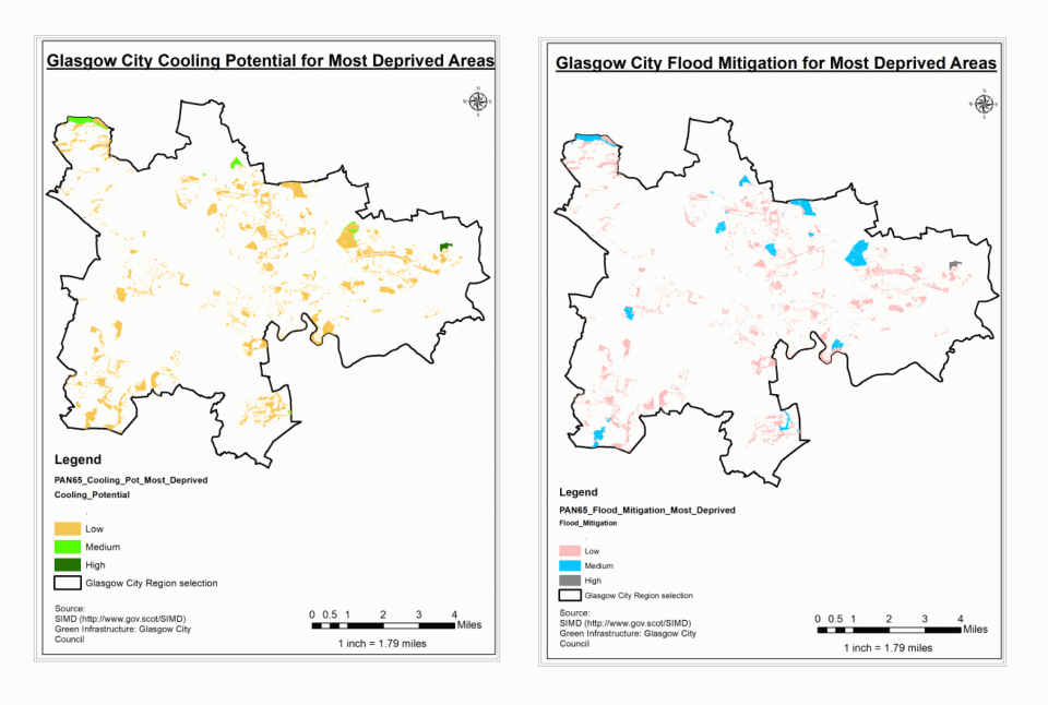
Finally, a deprivation rank of a given location was derived from the SIMD 2016 data and we have reported here the lowest decile datazones (i.e. the top 10% most deprived areas). This was then compared against the cooling and flood prevention potential maps to estimate the how ‘equitable’ is the availability of GI in Glasgow to minimize its key climate change risks in deprived areas.
Lessons
The city lab collaborated closely across the ‘academy-industry’ divide. The city was instrumental in giving the researchers access to the relevant data. The city authorities enumerated the policy aims and the challenges facing decision makers in equitably implementing these policies. Researchers brought to the table prior knowledge on relevant ecosystem services, underpinned by literature-based evidence. This indicates that the research choices, while being made by researchers, are informed by policy makers and practitioners so as to be relevant for practical application.
The ‘success’ of the exercise is the ability to showcase science-underpinned-evidence. The pitfalls are: robustness of the ‘evidence’ and its landscape scale-specific applicability.
- Availability of Green Infrastructure
- Deprivation
- Cooling potential of GI
- Flood prevention potential of GI
- Soil types within Glasgow City Council Area
The cooling and flood prevention potential of GI in Glasgow are shown below:

The incidence of deprivation in relation to GI-based cooling and flood prevention potential can be seen in the image below. This would give an overview of where GI-based interventions to enhance cooling and flood prevention need to be implemented to ensure that climate change action equally benefits all communities and is specifically targeted at the most deprived areas of the city which are more likely to house more of the city’s vulnerable communities.
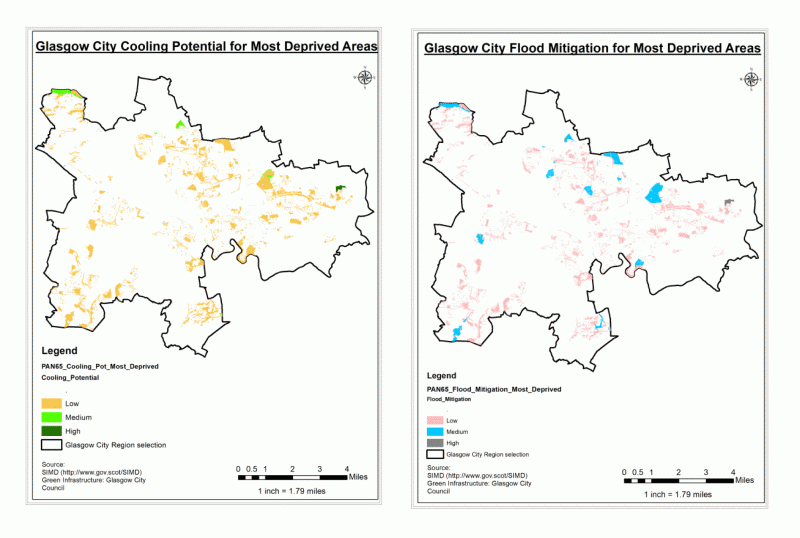
Using our approach, it is possible to identify areas within the city that are either able to mitigate overheating and flooding risks at the moment or in need of GI to mitigate these climate risks. It is also possible to identify areas where intervention would make the greatest equitable impact. Thus, a more ‘just’ transition to a climate-resilient future could be achieved across the city.
The EnRoute City lab approach highlights the possibility to identify key intervention areas for climate change mitigation actions in an equitable manner. That such identification could be made by planners with relative ease, and with readily available and accessible data, is a positive demonstration made possible by the EnRoute project. However, improved data quality (especially in terms of extent, health and quality of the GI data) and more robust (i.e. evidence based) assumptions valid for the local context could increase the confidence in our approach. The approach may not be valid in all areas, especially those without a robust set of ‘well-being’ (or its reverse – deprivation) data.
Further information
There are three broad limitations to our approach: data quality, wider validity of assumptions underpinning the study and scalability. The GI data we used in the present case study was meant to be a spatial audit of various types of GI in the city, not its quality or health. Besides, GI parcels have been bifurcated by roadways and footpaths that may not have an effect on the said GI’s effect on cooling and/or flood prevention. Correction of these errors is highly time consuming and would require extensive ground truth verification. Furthermore, the GI typology available for Scotland is not fully compatible with GI typologies typically used for the estimation of ecosystem services (in our case flood prevention and cooling). This required broad assumptions to be made and these may or may not hold for all areas. Finally, our approach may not be readily transferred to other cities. For example, while the availability of well-being (or lack thereof) data in the UK is very good, there are wide variations in the approach even within the UK. Cities in other countries may not have such comprehensive data. It is also necessary to indicate the need for more fine-scale information on ecosystem services provided by urban GI (especially on cooling potential and flood prevention potential). Performance of GI under changing climate (both in terms of its health as well as its ability to provide expected levels ecosystem services) remains unknown.