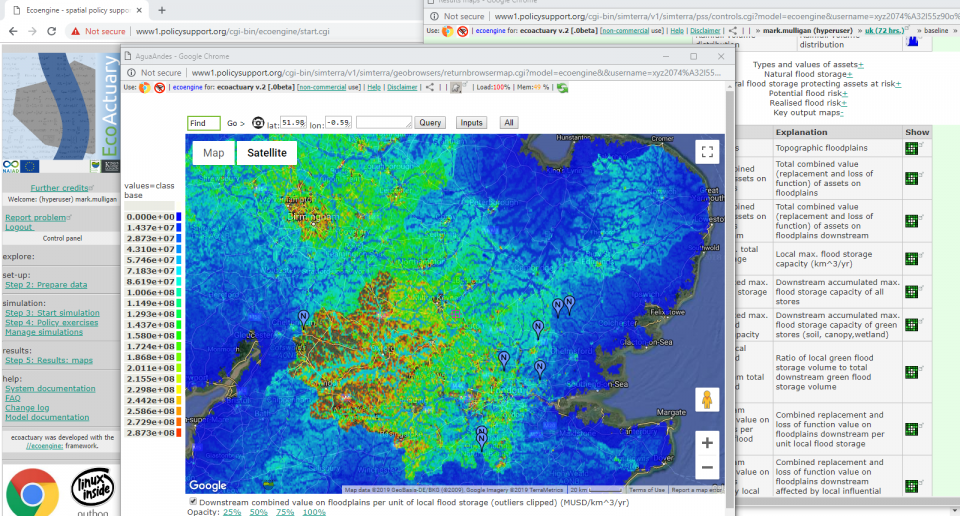
The Thames basin has a population of 13 million. A number of tributaries of the fluvial Thames suffer regular local flooding, flow monitoring in these upstream areas is sparse. The UK government has granted £15m for Natural Flood Management and interest in NFM in 2017, with a focus on point interventions such as leaky dams and retention ponds. Conservation Agriculture is also being practised by farmers and this may provide a significant contribution to flood storage and is an example of an areal NFM. We seek to build and test global tools for investors in NFM and catchment managers, and provide evidence for their effectiveness and co-benefits, using these point and areal NFM interventions as test cases. We use both modelling (Eco:Actuary) and monitoring (SmartRiver) techniques, and use Freestations (www.freestation.org) to provide low-cost IoT connected monitoring to assess the contribution of NFM to mitigate flooding downstream.
Using the widely used Policy Support System tools at www.policysupport.org as a basis, we built an insurance industry-relevant policy support system called Eco:Actuary. The objective of this project is to to co-develop and test the Eco:Actuary with NAIAD project partners & stakeholders in the fluvial non-tidal Thames as a DEMO catchment in the NAIAD project.
EcoActuary is an open-access catastrophe model capable of assessing the impact of NBS on local and downstream assets at risk of flood. It simulates a minimum of 1200 spatial events of a given intensity and volume drawn from a user-specified distribution and simulates the the economic value of downstream assets at risk of flood and the role of GI and NBS in securing this value.
EcoActuary is also capable of analysing the impacts of scenarios for land use change, land management and climate change on the economic value of assets at risk of flood
We have applied Eco:Actuary, a series of tools, to operationalise strategic planning and investment for Natural Flood Management in the Thames basin.
Flood mitigation is an important ecosystem service provided by natural capital. The same natural capital has a variety of co-benefits. Both natural capital and co-benefits can be mapped using Co$tingNature.
Managing these benefits involves the protection of existing natural capital but also the development of new natural capital, through investments in Natural Flood Management. These investments must be strategically placed to make a difference. Eco:Actuary can help plan and locate the best sites for investment. There are two tools: (1) Eco:Actuary investment planner examines scale of intervention needed and (2) Eco:Actuary spatial model helps users understand where to invest for maximum return on investment.
NBS Interventions must also be monitored for their effectiveness: //Smart:River measures the impact of interventions on flood peak reduction downstream directly and in real time, connecting through the Internet of Things. Our //Smart:River web connected, low cost, DIY sensors from the FreeStation project are monitoring the contribution of leaky dams, retention ponds and conservation agriculture to flood mitigation at sites throughout England.
Eco:Actuary is a global tool that is being tested in the Thames catchment. When the final version is released, it will be able to:
-
Assess assets at risk
-
Determine maximum influence of point (eg leaky dam) and areal (eg Conservation Agriculture) Natural Flood Management (NFM) on downstream flow and flood risk
-
Assess the (non-economic) co-benefits of protecting the hazard mitigation function for a basin
-
Implement scenarios for NBS and assess the implications for flood risk and insurance value
-
Assess spatial flood risk to valuable assets under current and climate change conditions.
6. Part of Eco:Actuary is SmartRiver which provides real time understanding of contribution of NBS/NFM to flood peak mitigation through web-connected, low cost, open source design field instrumentation
- Developing climate change adaptation; improving risk management and resilience
- Flood peak reduction
- Increase infiltration / Water storage
- Increasing infiltration
- Reduce drought risk
- Reduce flood risk
- Reduce load to sewer system
- Reduce risk of damages from drought
- Reduce run-off
- Developing climate change mitigation
- Carbon sequestration and storage
- Restoring ecosystems and their functions
- Improve connectivity and functionality of green and blue infrastructures
- Increase achievements of biodiversity targets
- Increase Biodiversity
- Increase quality and quantity of green and blue infrastructures
- Increased cultural richness and biodiversity
- Enhancing sustainable urbanisation
- Changing image of the urban environment
- Creation of green jobs relating to construction & maintenance of NBS
- Improve water quality
- Increase amount of green open spaces for residents
- Increase awareness of NBS solution & their effectiveness and co benefits
- Increase communities’ sense of ownership
- Increase population & infrastructures protected by NBS
- Increase social interaction
- Increase stakeholder awareness & knowledge about NBS
- Increase well-being
- Increase willingness to invest in NBS
- Provision of health benefits
- Social learning about location & importance of NBS
Eco:Actuary is a global model like its cousins Co$ting Nature and WaterWorld, and is applicable anywhere in the world on the basis of data provided.
- Models like Eco:Actuary are appropriate for large scale NFM strategy planning.
- Measurement through low cost, connected instrumentation is most appropriate for assessment of in situ NFM effectiveness (SmartRiver).
This project has received funding from the European Union’s Horizon 2020 research and innovation programme under grant agreement No 730497.
- Urban planning strategies
- Strategies actions
www.policysupport.org/smart
www.freestation.org
www.policysupport.org/costingnature
Mark Mulligan. Department of Geography, King's College London. mark.mulligan@kcl.ac.uk
Sophia Burke, AmbioTEK CIC, sophia.burke@ambiotek.com
