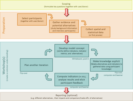
Resource description:
The QUICKScan software and QUICKScan tool (http://QUICKScan.pro) encompasses a modelling environment with functionalities to assess societal and environmental conditions, diagnose patterns and interactions, implement alternative responses and evaluate the impacts of those responses. The QUICKScan software and QUICKScan tool (http://QUICKScan.pro) encompasses a modelling environment with functionalities to assess societal and environmental conditions, diagnose patterns and interactions, implement alternative responses and evaluate the impacts of those responses. QUICKScan is an empty modelling shell which needs to be filled on a case by case basis with GIS data, qualitative and/or quantitative rules, and map algebra.
Author/Contact:
Dr Paula Harrison,
Land Use Group,
Centre for Ecology and Hydrology,
Lancaster Environment Centre,
Library Avenue,
Bailrigg,
Lancs,
LA1 4AP
+44 (0) 1524 595858
Images
Requirements:
- The QUICKScan software encompasses a modelling environment that needs to be filled with spatial and/or statistical data during the preparation phase. Depending on the topic case study data is either already available in the QUICKScan tool (e.g. EU level,
- QUICKScan can be used in single, multi and trans (involving stakeholders) disciplinary research and requires appropriate input depending on the focus.
- Two versions of the software exist: 1. Community-edition: Light-weight latest version with up to 10 user defined rules. No support provided. 2. Ultimate edition: Full featured, latest stable version with an installation set, a user manual, support and fre
Advantages:
- QUICKScan is spatially-explicit.
- It can easily combine and handle a wide variety of different spatial data and knowledge rules.
- It has an open model structure with a direct response to all the implemented expert knowledge rules. This is often highly valued and seen as a possible future advance for more in-depth modelling approaches. The transparency of QUICKScan enables the easy t
Constraints:
- Limited to spatially-explicit issues.
- No system dynamics, no feedback loops.
- Currently restricted to use with ArcGIS 10.0.
Licence:
- Free, no licence
Development stage:
- Full, working product
- methodfactsheetquickscan.pdf (1.23 MB)
