

Resource description:
We use sophisticated modelling to identify, rank and prioritise Nature-based Solutions to multiple problems such as flooding, water resource supply, river pollution, soil loss, poor farm management and biodiversity loss. Our engaging communications show best bang for buck actions, with many informed options to aid participatory design.
Viridian solves problems such as through carefully targeted enhancement of the natural environment. We use sophisticated modelling to identify, rank and prioritise a range of such ‘Nature-based Solutions’. We create engaging communications showing what to do where to deliver best bang for buck, but also offering stakeholders a huge range of options to aid participatory design.
Our solutions work from street to regional scale and are perfect for policy development, project planning, funding applications, economic appraisals and integrating with traditional engineering.
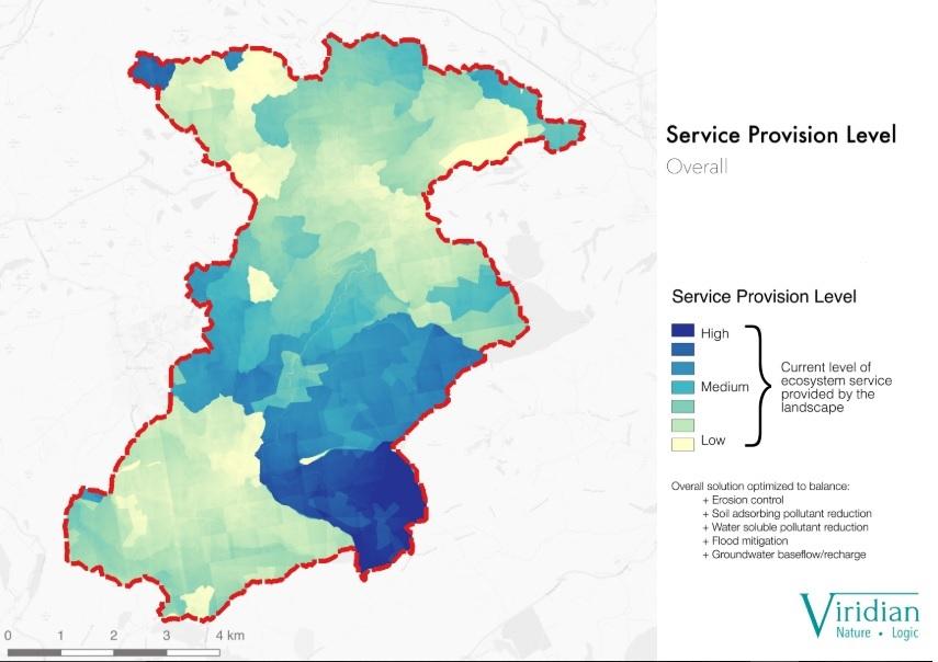
Viridian models entire catchments to identify which habitats should be created and where to create then to most reduce local problems: a prioritisation of what to do where to give best bang for buck.
We concentrate first on natural flood management, diffuse pollution (soluble and adsorbed), erosion/siltation and groundwater recharge. We can then integrate these solutions with more standard ecosystem service modelling, such as carbon, habitat connectivity and recreation.
We can incorporate all sorts of restrictions and requirements into our models, such as ecological considerations; and can quantify the benefits of many services, including flooding.
Author/Contact:
Viridian Logic: Angus Middleton, Director, angus@viridianlogic.com, 07779 339993
Images
Requirements:
- Can use mainly open source data, but minimum standards are necessary.
- Local priorties and problems need to be defined before Viridian modelling, since we solve problems rather than identifies them.
Advantages:
- Low cost modelling from site to regional scale that identifies optimal solutions to local problems.
- Quantifies ecosystem service benefits, such as the reduction in peak flood heights delivered by any combination of the modelled, natural solutions.
- No client experise needed in data, GIS, hydrology or nature-based solutions; tell us your aspirations and we will deliver the completed model outputs as GIS layers or simple, easily-understood maps.
Constraints:
- Viridian modelling does not identify problems: we provide best solutions to previously-identifies problems.
- Poor data availability or resolution will affect the usefulness of the model outputs, although sufficient data is available in most EU countries.
- Quantifying many ecosystem services can be problematic due to the range of methods and metrics to do so. For instance, there are many carbon prices that could be used for valuing forest carbon storage.
Uses of this resource:
- Landscape planning to maximise nature-based solutions: we can model single sites or whole regions to understand what to do where to provide most single or multiple ecosystem services. We can do this within local constraints (such as protecting certain species) or priorities (such as social objectives).
- Natural Capital mapping and bio-physical quantification or qualification of related ecosytem service flows.
- Catchment management: we can show how to improve both water quantity and quality in rivers, help with groundwater recharge to reduce water stress, reduce siltation or rivers and reservoirs and improve the ecological health of the catchment. This can be integrated with wider ecosystem services, such as recreation or carbon storage, as well as ecological imperatives. Quantification of services means we can help with business planning, cost/benefit analysis and accessing external funding.
- Natural Flood Management (NFM) planning: we can prioritise the best places to create or restore natural habitats to most reduce local flooding at least investment, as well as specifying the most effective habitat type for each location. We can then quantify the volumes stored in the landscape, or the reduction in peak flood heights that any combination of our prioritised solutions will deliver. This allows NFM to be integrated with hard-engineered flod defenses and business planning systems, as well as improving cost/benefit analysis and funding applications.
- Biodiversity offsetting and banking: we can identify where creating the relevant habitats will provide the greatest degree of single or multiple ecosystem services.
- Infrastructure protection and risk reduction: we model how to use the landscape to best protect infrastructure from natural hazards, such as flooding and erosion. We can also do options analysis for proposed infrastructure locations.
Additional information:
The prioritisation modelling - which habitats to create and where to create them to most reduce local problems, with each intervention prioritised as to its effectiveness - cost from only €10 per square kilometre. This can include most data inputs, modelling, supply of GIS outputs and creation of maps.
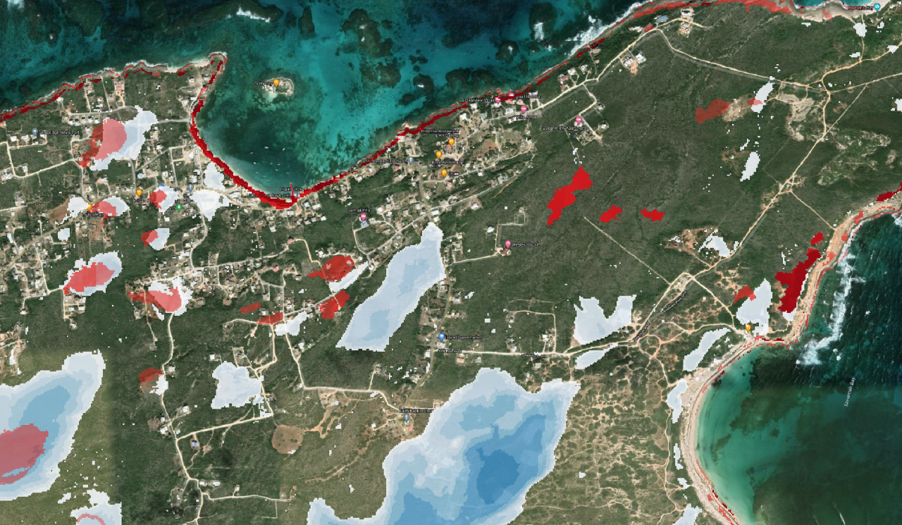
Team members modelled a Welsh catchment that was causing harmful siltation of a reservoir. They firstly used hydraulic flows to understand where erosion was occurring, then integrated this with vegetation and soil interactions to understand where putting interventions would most reduce silt entering the reservoir. The most efficient results were to plant native trees in three distinct parts of the catchment. A PhD also analysed the same problem, and came to very similar conclusions as the Viridian team members. Another model that used hydraulic flows to understand where erosion was likely to occur, but did not optimise for solutions, produced very different results. The local stakeholders group have started to plant trees in the locations suggested by the Viridian team members. A presentation of this project (undertaken by Landmark Information Group) can be found here http://prezi.com/5uxwfeyjhg4l/?utm_campaign=share&utm_medium=copy&rc=ex0share.
Viridian have undertaken a National Ecosystem Assessment of Montserrat, which assisted with the valuation of natural capital to the Montserrat economy. This project involved liaising with Montserrat stakeholders and focused on their aspirations. There was extensive data gathering, management, manipulation, modelling and presentation. The project also integrated with the creation of detailed habitat maps through satellite observations.
Licence:
- Commercial
Development stage:
- Full, working product
Quality assurance:
- Professional references
- Own QA and testing
- viridianflyercasestudies202012.pdf (1.68 MB)