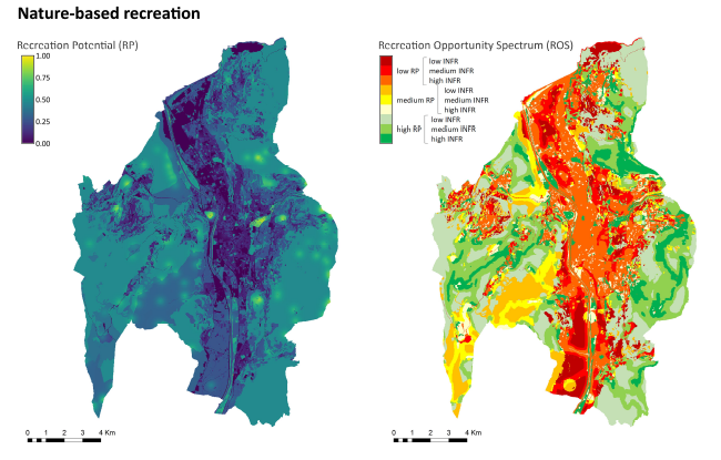
Nature-based recreation has been acknowledged as a key issue for the city of Trento, also in relation to policies aimed at increasing the availability of urban green areas and providing equal opportunities across the city. Compared to other urban contexts, day-to-day nature-based recreation in Trento presents some peculiar characters: due to the location of the city, many opportunities for “non-urban” recreational activities are available and enjoyed by citizens in the immediate surroundings of their homes (e.g., hiking, mountain-biking, climbing) However, the contribution of the different natural and non-urbanized areas in supporting such recreational activities is difficult to capture, and hardly considered in current planning and management of green infrastructures.
Together with Grazia, we proposed to test the applicability of the ESTIMAP recreation model to investigate the recreation potential and the associated spectrum of opportunities for the city of Trento. During a short visit period at JRC at the end of August, Chiara and Grazia worked at a first application, exploring the available data and the possible adjustments of the generalized model to better fit the specificities of the local case. Results from this first application were presented and discussed on the 19th of September with the municipal officers responsible for parks and green areas management, including the EnRoute representative Giovanna.
The maps received positive comments as a useful tool to summarize many ongoing reflections on the issue, and to potentially support planning decisions and management interventions. Particularly, the identification of areas with high potential but low availability of facilities and infrastructures and, on the other hand, areas with high accessibility and proximity but low potential was considered a starting point to set up different planning strategies. Moreover, we discussed the potential of the analysis to open up discussion with other people and offices interested in the issue from different perspectives, thus moving from a strictly sectoral approach to integration and co-design.
Since weighting of different factors is a critical input for the model, we decided to identify a list of experts eager to contribute to the analysis, including people from different municipal offices and practitioners. The next steps will be: a first contact with possible contributors, an on-line questionnaire to elicit weights from each expert independently, an updating of the model based on the results of the questionnaire, and the discussion of the new maps (and of possible adjustments, if needed) in a meeting with all the experts involved.
contact: Chiara Cortinovis chiara.cortinovis@unitn.it