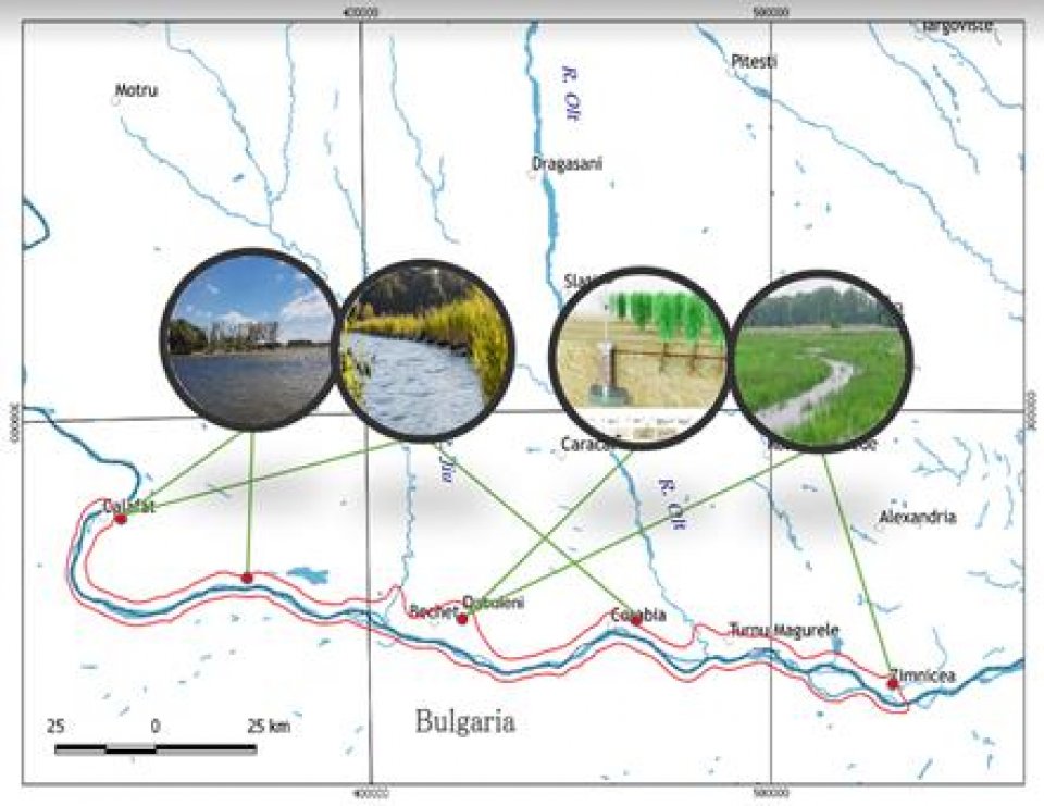
The Lower Danube demonstration site spans between Zimnicea and Calafat, starting at approximately 500 km upstream the Danube mouths, representing the border between Romania (on the left side) and Bulgaria (on the right side). The area is characterized by complex morphology and with different types of banks: on the left side low bank, exposed to erosion and on the right side high bank more stable. It covers around 800Km2 of land and includes two areas of confluence with two important tributaries: Jiu River (generally natural) and Olt River (a river with dams, hydropower plants and artificial lakes, that are concentrating pollutants inside the sediment bead).
The Lower Danube demo case includes both urban and rural areas as well as two Natura 2000 sites - ROSPA0010 Bistret (1.916 Ha) and ROSCI0039 Ciuperceni- Desa, including ROSPA0013 Calafat - Ciuperceni - Danube, Ciuperceni - Desa , Balta Lată, Balta Neagră (29.206 Ha).
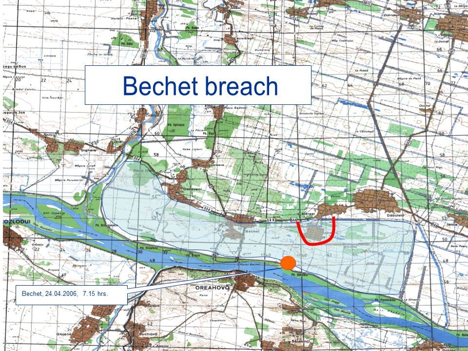
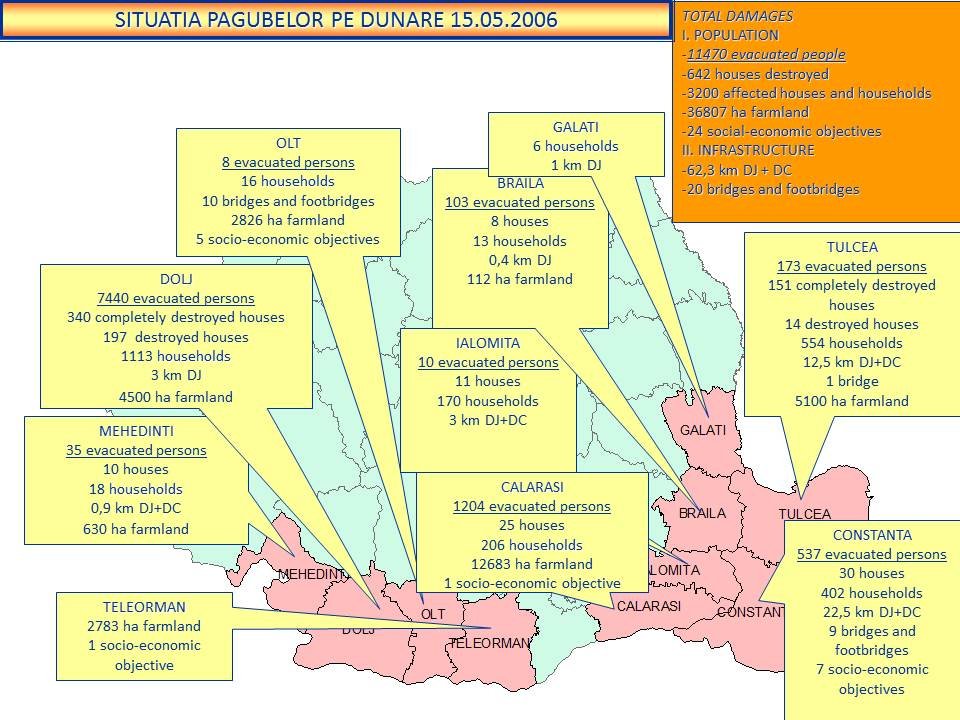
The Lower Danube region is an important European wetland ecosystem that has lost nearly 80% of its wetlands in the last century due to attempts at river dredging, land reclamation and flood control (source: www.icpdr.org). Anthropic interventions along the Danube river water course, such as construction of the hydropower’s Iron Gates I Lake and Iron Gates II Lake (artificial lakes) and along its banks through embankment, have generated high bank erosion processes, floods and droughts, as well as changes of the riverbed with negative impact on navigation. So today, there are problems with desertification areas – the area of Dăbuleni is called: ”Sahara of Oltenia”, with floods – starting with the severe one in 2006 – that had impact along the whole Lower Danube (see below picture) and the ones occurring when Danube flow is too high in rainy spring.
Romania faces two main challenges when it comes to water risks mitigation:
- firstly, its multilevel governance is based on a complex legal framework (with over-regulation through the secondary and tertiary levels of legislation), which impacts the disaster reduction measures generally,
- Secondly, a high number of stakeholders with very diverse profiles, restricted legal competencies and limited technical expertise who lack awareness of ecosystem services and their insurance potential.
The generalized top-down approach creates dependency on centralized interventions and generates a lack of a long-term vision required for an acknowledgement of the value of NbS and green infrastructure services. This results in ambiguity for water-related risks awareness and lack of efficient prevention actions at a local level.
Slideshow:

The Lower Danube demo case has as main objective to create an efficient network of national, regional and local stakeholders in order to apply collaborative approach for water security measures and extreme meteorological events mitigation by using the ecosystem service and green infrastructure. In the NAIAD project the Lower Danube demo case study is focused on understanding the social risk perception and challenges for NbS implementation, to open business opportunities for insurance sector and to identify potential business model to foster Nature Based Solutions implementation and acceptance for reducing water-related risk through stakeholders’ engagement by co-benefits identification.
In Lower Danube demo we have done up to now three rounds of interviews at national, regional and local level for the Institutional analysis and modelling of the social risk perception. Also, two stakeholders workshops and a focus group (in the focus area of Potelu) were organized in cooperation with WWF Romania (enhancing NbS acceptance for reducing water-related risk through stakeholders’ engagement in co-benefits identification). A multi-step approach was and is being used for ensuring continuous and effective involvement of stakeholders, through both individual and participatory activities.
We have also done practical work in the field by installation of sensors (Free Stations) and delivered data input for the ECO:ACTUARY and Co$tingNature, developed by Kings College London, which should further support development of potential business cases for NbS implementation in Lower Danube demo.
The ECO:ACTUARY platform is useful for mapping data on ecosystems, climate, land use and allows the assessment of damages from hazards. In the case of flood hazards, ECO:ACTUARY will include relative damage curves that will be functions of the height of water in the flood and the height of the asset. Nineteen different types of assets are considered: residential, industrial, cropland, pastures, and other type of public assets and infrastructures. The assets values are inferred from nightlight satellite images so ECO:ACTUARY can be used with alternative databases of assets and damage functions.
In Lower Danube demo we managed also to bring into the light the role of ecosystems in water management for flood and droughts protection and their added insurance value – IVE (or damage avoided). So, after the IVE survey, we built a strong connection with the insurance sector, NAIAD project being presented during insurance events in 2018 and 2019.
Further on, after the real NbS cases already implemented were documented, the goal is to identify a proper business case, suitable for bank financing and the transactions needed for implementation.
Enhancing the information sharing processes within the interaction network in which the different actors are embedded could not be enough to enable an effective collective action for climate change adaptation. Decision-makers need to cope with uncertainty due to ambiguity in problem understanding and in multi-actors setting the presence of ambiguity is unavoidable. Therefore, we have used the Participatory Approach based on the key principles of System Dynamics.
Further on, for the semi-structured interviews done, we created elaborate Fuzzy Cognitive Maps or on shortly FCM. It is a cognitive map, where concepts are variables defined with fuzzy values and connections are defined as fuzzy weights describing the strength of the causal relationship between two variables. The connection strength indicates also how the stakeholders perceived influence of two concepts on each other.
Further on, the lists of potentially interesting co-benefits and ecosystem services associated to the selected societal challenges were defined during workshop and individual inputs were collected and aggregated. The aggregation of stakeholder inputs allowed us to select the most important co-benefits, to be used for supporting the co-design of desired NbS for the Lower Danube demo site.
Below is the list of benefits and co-benefits identified in the Lower Danube demo case:
|
Expected benefits and co-benefits |
Average score |
|
Increase biodiversity (Increase Ecosystem State) |
10 |
|
Increase the quality and quantity of green areas |
10 |
|
Increase water storage |
9 |
|
Increase rural ecological tourism |
9 |
|
Increase community wellbeing |
8,5 |
|
Flood peak reduction |
8 |
|
Increase fishing productivity |
8 |
|
Increase water availability for irrigation |
7,5 |
|
Increase community’s awareness and knowledge about the risk management measures |
6,5 |
|
Increase community risk awareness |
6,5 |
|
Increase public participation in risk management measures design |
6,5 |
|
Increase business productivity (industrial + agricultural) |
6,5 |
|
Increase the population protected by risk management measures |
6 |
|
Reduce bank erosion |
6 |
|
Minimize erosion/solid transport in the river |
6 |
|
Improve coordination of risk management strategies within and across level of governance |
5,5 |
|
Reduce built environment damages (i.e. building, infrastructures) |
5,5 |
|
Increase agricultural productivity |
4,5 |
|
Social justice and social cohesion |
4 |
The potential Nature Based Solutions in the Lower Danube demo case were decided through public consultations and participative approach with the stakeholders who were involved from the beginning of the NAIAD project. The proposed solutions are:
- to reconnect the Danube flood plain,
- to restore the former ponds and to setup forest windbreak network in order to achieve the flood peak reduction,
- increase the quality and quantity of green areas and to increase biodiversity.
Further research is still needed regarding the exact location(s), determining the NbS to be applied, the design of the NbS, as well as identification of potential financing sources for implementation and monitoring.
- Developing climate change adaptation; improving risk management and resilience
- Reduce drought risk
- Reduce flood risk
- Greater ecological connectivity across urban regenerated sites
- Increase awareness of NBS solution & their effectiveness and co benefits
- Increase population & infrastructures protected by NBS
- Increase stakeholder awareness & knowledge about NBS
- Increase willingness to invest in NBS
- Social learning about location & importance of NBS
Taking further the work done up to now towards a collaborative water risks management, we will define and describe scenarios and strategies together with the local stakeholders. To be assessed in a forward-looking perspective strategies that incorporate NbS for water risk management, we need a participatory modelling of future scenarios for the land use, economic development and regulations. To be successful, Nature Based Solutions have to be socially and economically accepted. As the implementation of a NbS is usually connected with regional development and long-term use of land, its implementation will rely on the local administration, therefore defining future scenarios that include benefits and co-benefits for local communities will enhance the social acceptance of NbS.
A new workshop is planned, in order to gather relevant stakeholders and collectively define an effective spatial location of selected measures in the area. Additionally, participatory exercises will be performed
in order to both validate scenarios and strategies, with specific focus on indicators to value the production of co-benefits.
We also expect that ECO: ACTUARY and Co$tingNature methods will help us finalize the economic analysis in order to elaborate a financing framework and potential business models for bankable implementation projects.
During the two workshops done, multiple benefits have been underlined, brought by restoration of wetlands in the Lower Danube demo specifically, as well as in general:
- mitigation of peak floods and restoration of the natural resilience of the environment,
- improvement of environmental conditions for the development of biodiversity,
- offering opportunities for eco-tourism, fishing, and grazing,
- diversifying the local economy.
The main beneficiaries of our research will be the local communities, not only regarding the flood protection, but also regarding the fructification of the potential co-benefits. In contracts with the grey flood prevention infrastructure that is planned at river basin scale and has more solid financing sources, the green infrastructure relies largely on local communities - first for acceptance, and then for implementation, monitoring and maintenance. Especially in Lower Danube demo, where NbS are located in rural areas, where farmers and local population are users, owners or administrators of land resources and have their own way of using it. Therefore, to ensure acceptance of NbS at the local level, local communities as well as local administrations need to be engaged in decision-making processes for design and implementation.
After the catastrophic floods of 2006 the Romanian government has approved “the Program for Ecologic and Economic Reshape of the Danube Floodplain within the Romanian sector”. The project was implemented by National R&D Institute for Danube Delta Tulcea (INCDDD) and finalized in 2008. Among its priorities it included reconsideration of the defense lines against floods of settlements, restoring some embanked areas in order to setup wetlands for biodiversity conservation and evaluation of economic potential within these embanked areas in the context of the wetlands restoration. Afterwards, a series of projects promoting NbS were implemented by National Administration Romanian Waters during 2006-2014.
The NAIAD project is providing support for local collaboration and engagement of local stakeholders in decision-making and policy setting and is contributing to building a strong framework for effective adoption of Nature Based Solutions for water risk management. Good governance of NbS requires creating local partnerships and identifying clear roles within those partnerships, where local stakeholders’ knowledge of resources can play an important role. In addition, local administrations need capacity building on implementation, management and monitoring interventions on the ground, therefore NAIAD project in Lower Danube demo is working with both communities at the local level and decision-makers at national level to align policy and practice.
The benefits and co-benefits of NbS become apparent when used as the tools of long-term administrative strategies. These strategies need both informed political decisions, as well as a societal commitment to well-structured approaches to problem-solving.
This project has received funding from the European Union’s Horizon 2020 research and innovation programme under grant agreement No 730497.
Albert Scrieciu, Lower Danube Demo Leader in NAIAD Project , Geoecomar
|
|
Florentina Nanu, BDG - Business Development Group
|
|
Raffaele Giordano, CNR-IRSA
|